Kerala Floods and Central Water Commission Report | SP Ravi
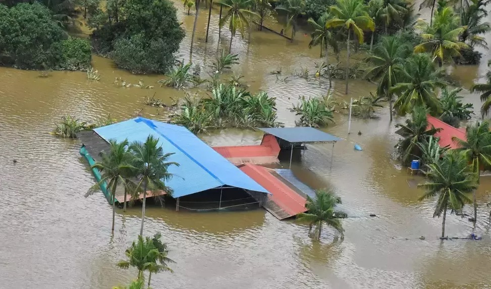
The dawn of the 72nd Independence Day was extremely wet in most parts of Kerala. The latest spell of heavy rainfall that started on the previous day had already inundated many low lying areas. It only got intensified further. Over the next 48 hours, the state was impounded with extremely heavy rainfall. The result was the most severe floods after 1924 – in local parlance the ‘Thonnootti Onpathile Vellapokkam’ (flood of 99) taking after the Malayalam year of 1099. The South – West monsoon was very active in the state ever since it set in on 29th May, 2018. The state received 15 per cent and 18 per cent excess rainfall in June and July, with a few heavy rainfall spells resulting in hundreds of landslides/ landslips and also flooding. The rainfall from 1st to 19th August was higher by a whoping164 per cent (758.6 mm against the average of 287.6 mm) with the bulk coming in two spells between the 8th and the 17th. Thirty five dams across various river basins opened their shutters on 15th, 16th and 17th, compounding the flood situation. The records placed before the state legislative assembly say ‘55 lakh people from 981
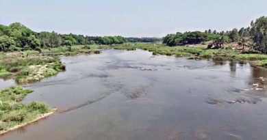
villages were affected since the beginning of monsoons, 483 people lost their lives and 14 missing, 14,50,707 people from 3,91,494 families were shifted to 3879 relief camps’. The Periyar, Pamba and Chalakudy river basins in central Kerala were the worst affected. They also happen to be the most dammed rivers of Kerala.
The UN Secretary General is reported to have demanded strong action on climate front, citing Haithi and Kerala floods as extreme climatic events. The link with climate change may be an issue of debate. But with the floods in Utharakhand (2013), Kashmir (2014), Chennai (2015) and a host of other extreme weather events and the latest being the Kerala floods there is urgent need to further our deliberations on climate change leading to quick and substantial climate actions — from both the government and public – including upward revision of India’s INDC (Intended Nationally Determined Contribution).
It’s commendable that Central Water Commission has come up with a report on the floods, titled “Study Report – Kerala Floods of August 2018” within two weeks after the floods. Due to the time constraint, some of the inadequacies in the report can surely be pardoned. However, given the fact that this is the highest body on water at the national level under the ministry of water resources, one would not have expected them to post picture from Kashmir floods on the cover of the report. Some other statements like “first onset of floods occurred towards end of July”, whereas it had occurred on 15th and 16th of July could and should have been avoided. The statement that “fury of 1924 flood levels in most of the rivers was still fresh in memory of people of Kerala”, is interesting, as we are talking about an incident that happened 94 years ago!. Given the limitations of analysis as pointed out in the report, this could have been termed a preliminary report so that we could have expected a more detailed report, based on in-depth analysis of facts and figures.
Along with the extremely heavy rains, flaws in reservoirs operations are also alleged to have contributed to the heavy floods. Reading through the CWC report, one cannot be faulted in believing that this was an exercise, intended at justifying the dams operations. A major part of the report has been dedicated to discussing reservoirs operations during floods. It provides analysis of Idukki and Idamalayar projects across Periyar, Kakki reservoir across Pamba River, Malampuzha across Bharathapuzha, Kerala Sholayar, Parambikulam and Thunakkadavu across Chalakudy River and Banasurasagar in Kabani. Based on these analyses, the CWC concludes that “the dams in Kerala neither added to the flood nor helped in reduction of flood, as most of the dams were already at FRL or very close to FRL on 14 August 2018, due to more than normal rainfall in the months of June to July 2018”. Unfortunately, a closer scrutiny of the analysis would show unsustainable arguments and also some significant gaps.
The report admits that there was 13 MCM (Million Cubic Meters) more release from Malampuzha dam during the floods, than the inflow into the reservoir, but argue that it is insignificant when compared to the total flow of 1510 MCM at the CWC river gauging station at a place called Kumbidi in the downstream of the river. In fact, the inflow and outflow at Malampuzha during 15 -17 August were 35 MCM and 66 MCM respectively as provided in table 14 of the report and hence the excess discharge was 31 MCM and not 13 MCM. And, the outflow was about 85 percent higher than the inflow. Even though there are 5 gauging stations on Bharathapuzha with four of them below Malampuzha dam, they have only looked at the lowest station that receives water from 5787 sq.kms, whereas Malampuzha deals with a catchment area of 145 sq.kms only. More importantly, severe flooding in the basin was felt at places just below the Malampuzha dam, including Palakkad town. By arguing that the excess discharge from an upstream dam that covers only 2.5 percent of the catchment area is insignificant in comparison to the total river flow near the river mouth is a classic case of comparing the incomparable.
The report claims that the Idukki project achieved flood moderation to the tune of 60 MCM over the three day period. However, unlike at Malampuzha, the CWC did not find it necessary to compare the volume of flood moderation at Idukki with the total runoff of 1925 MCM at their gauging station at Neelaswaram in the lower reaches, even though the flooding in Periyar basin had severely affected the downstream. The report admits that Idamalayar project in the same basin could not help in achieving flood moderation as it was full before the start of the heavy rainfall spell and it is silent on releases from smaller projects across the river and also failed to analyse the data at Bhoothathankettu barrage that receives all the waters from the upstream projects. More importantly, the report, while discussing individual projects, doesn’t discuss the need for a basin planning for flood management.
The report mentions that the Banasurasagar across Kabani, reservoir was at FRL since July 16th, but doesn’t attach any significance to it. In fact this was the case with many reservoirs in the state, including Kakki in Pamba and Kerala Sholayar and Poringalkuthu across Chalakudy River and there was no attempt from dam authorities at reducing water level during lean periods of monsoons, even though more heavy rains were to be anticipated. The report does admit that Kakki dam could not help in moderation of floods in Pamba River.
At Chalakudypuzha, the figures provided by CWC are substantially lower than that available from other sources. The rainfall at Tamil Nadu Sholayar and Kerala Sholayar on the 15th is shown as 170 and 160 mm respectively in table 11. However, the figures available with the respective dam authorities give rainfall at 410 and 350 mm respectively. The flood discharges from both Parambikulam and Kerala Sholayar are substantially higher than that shown in the report. These dams had a combined peak discharge of about 72,000 cusecs (more than 2000 cumecs or 20 lakh liters per second) post midnight of 15th. The flow rate at Poringalkuthu, including yield from it’s own catchments is likely to have been around 3500 cumecs. This resulted in the extremely dangerous situation of water flowing more than 2 meters above Poringalkuthu dam. The CWC report says the data at Aarangali river gauge station, about 40 kms downstream of Poringalkuthu shows maximum flow of 2900 cumecs only on 16th morning, whereas actually it should be close to 4000 cumecs. The report admits that reading could not be taken from some sites due to flooding, without naming the sites. It’s highly unlikely that the readings at Aarangali were taken on 16th and 17th.
Even while exonerating the dams from the causes of floods, the report does suggest that it is essential to review the rule curves of all reservoirs in Kerala. The claim in the report that “Even, with the 75 percent-filled reservoir conditions, the current flood could have not been mitigated as 1-day rainfall in majority of the area was more than 200 mm and severe rainfall continued for 3 to 4 days” cannot be accepted. It needs to be noted here that the area of inundation increases exponentially with each meter increase in flood level. Had there been about 25 percent storage space, it would have totally changed the reservoir operations and the peak discharge could have been reduced significantly, resulting in considerable reduction in maximum flood levels. Recommendation for storage dams across Meenachil, Manimala and Achenkoil rivers is totally uncalled for and is contradictory to the observations in the report that the existing dams could not have achieved flood moderation, even if it had some storage space.
Courtesy: River Research Centre